
Īxiptli:Map of USA AK full.png
Ahmo oncah occe cualli īxiptli.
Map_of_USA_AK_full.png (284 × 184 pixel; tlaixiptlayotl octacayotl: 19 kB; machiyotl MIME: image/png)

|
File:Map of USA AK full.svg es una versión vectorial de este archivo. Debería usarse esa versión en lugar de este archivo PNG, cuando sea mejor.
File:Map of USA AK full.png → File:Map of USA AK full.svg
Para más información, lee Ayuda:SVG. |
 |
Tlacecempohualoni
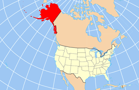
| Tlacemmelahualiztli | Map of USA with Alaska highlighted and shown in true position |
| Mactli | |
| Tzintiliztli | http://www.nationalatlas.gov/printable/reference.html |
| Autor | |
| Otras versiones | File:Map of USA AK full.svg |
Licencia
This map was obtained from an edition of the National Atlas of the United States. Like almost all works of the U.S. federal government, works from the National Atlas are in the public domain in the United States.
Online access: NationalAtlas.gov | 1970 print edition: Library of Congress, Perry-Castañeda Library
|
Amatl itlatolol
Haz clic sobre una fecha y hora para ver el archivo tal como apareció en ese momento.
| Tonallapohualpan ihuan imman | Pilixkopintsin | Octacayotl | Tekitiketl | TlahtoIcaquiliztiloni | |
|---|---|---|---|---|---|
| naman | 20:43 17 Tis 2012 | | 284 × 184 (19 kB) | Ras67 | cropped |
| 16:31 2 Nāuh 2007 |  | 286 × 186 (20 kB) | MattWright | fix to more standard map colors | |
| 06:20 2 Nāuh 2007 |  | 286 × 186 (19 kB) | MattWright | {{Information |Description=Map of USA with Alaska highlighted and shown in true position |Source=http://www.nationalatlas.gov/printable/reference.html |Date=2007-04-02 |Author= |Permission= |other_versions= }} Category:Maps of the United States [[Cat |
In canin oquitlalihqueh
Ahmo oncah tlahcuiloliztli tlein quitzonhuilia nican.
can nohuiyanyoh motequipanoh inin tlachiyaliztecpaliztli
Las wikis siguientes utilizan este archivo:
- Uso en am.wikipedia.org
- Uso en ar.wikipedia.org
- Uso en az.wikipedia.org
- Uso en az.wiktionary.org
- Uso en ba.wikipedia.org
- Uso en bn.wikipedia.org
- Uso en ce.wikipedia.org
- Uso en cy.wikipedia.org
- Uso en da.wikipedia.org
- Uso en de.wikipedia.org
- Uso en el.wikipedia.org
- Uso en en.wikipedia.org
- Uso en es.wikibooks.org
- Uso en fa.wikipedia.org
- Uso en fr.wikinews.org
- Uso en ga.wikipedia.org
- Sitka
- Buirg Aleutians Thoir, Alasca
- Buirg Anchorage, Alasca
- Buirg Artach Thiar Thuaidh, Alasca
- Buirg Bristol Bay, Alasca
- Buirg Denali, Alasca
- Buirg Fairbanks Réalta Thuaidh, Alasca
- Buirg Haines, Alasca
- Buirg Juneau, Alasca
- Buirg Leithinis Kenai, Alasca
- Buirg Tairseach Ketchikan, Alasca
- Buirg Oileán Kodiak, Alasca
- Buirg Loch agus Leithinis, Alasca
- Buirg Matanuska-Susitna, Alasca
Ver más uso global de este archivo.