
Īxiptli:Bobcat Lynx rufus distribution map.png

Tzintiliztlahcuilolli (704 × 800 pixel; tlaixiptlayotl octacayotl: 124 kB; machiyotl MIME: image/png)
Tlacecempohualoni
| Tlacemmelahualiztli |
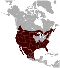
English: Geographical distribution of the Bobcat Lynx rufus, with national borders added. The map was created using the Generic Mapping Tools, GMT, version 5.1.1. |
| Mactli | |
| Tzintiliztli |
Trabajo propio utilizando: the IUCN Red List spatial data to draw the borders of the Lynx rufus range: Este mapa fue creado con GMT. |
| Autor | Darekk2 using the IUCN Red List spatial data |
| Otras versiones |
|

Licencia
Attribution: The author of the work and the IUCN Red List spatial data.
You must provide the appropriate credit for the IUCN Red List spatial data:
IUCN (International Union for Conservation of Nature) 2008. Lynx rufus. In: IUCN 2014. The IUCN Red List of Threatened Species. Version 2014.3. http://www.iucnredlist.org. Downloaded on 25 February 2015.
and the IUCN Red List spatial data
- Tihuelitiz:
- de compartir – de copiar, distribuir y transmitir el trabajo
- de remezclar – de adaptar el trabajo
- Bajo las siguientes condiciones:
- atribución – Debes otorgar el crédito correspondiente, proporcionar un enlace a la licencia e indicar si realizaste algún cambio. Puedes hacerlo de cualquier manera razonable pero no de manera que sugiera que el licenciante te respalda a ti o al uso que hagas del trabajo.
- compartir igual – En caso de mezclar, transformar o modificar este trabajo, deberás distribuir el trabajo resultante bajo la misma licencia o una compatible como el original.
Amatl itlatolol
Haz clic sobre una fecha y hora para ver el archivo tal como apareció en ese momento.
| Tonallapohualpan ihuan imman | Pilixkopintsin | Octacayotl | Tekitiketl | TlahtoIcaquiliztiloni | |
|---|---|---|---|---|---|
| naman | 23:53 26 May 2015 | | 704 × 800 (124 kB) | Darekk2 | thicker borders of states |
| 17:30 20 Yēt 2015 |  | 703 × 800 (117 kB) | Darekk2 | removed transparency of the background | |
| 16:19 15 Yēt 2015 |  | 703 × 800 (129 kB) | Darekk2 | previously an incorrect map was used as the background, the range in Mexico was incomplete | |
| 16:10 15 Yēt 2015 |  | 800 × 771 (139 kB) | Darekk2 | uncovered Lake Superior ... | |
| 16:09 25 Ōnt 2015 |  | 705 × 800 (128 kB) | Darekk2 | User created page with UploadWizard |
In canin oquitlalihqueh
Ahmo oncah tlahcuiloliztli tlein quitzonhuilia nican.
can nohuiyanyoh motequipanoh inin tlachiyaliztecpaliztli
Las wikis siguientes utilizan este archivo:
- Uso en en.wikipedia.org
- Uso en fy.wikipedia.org
- Uso en tr.wikipedia.org
- Uso en vi.wikipedia.org