
Īxiptli:Manaus-Amazon-NASA.jpg
Tamaño de esta previsualización: 600 × 600 pixels. Otras resoluciones: 240 × 240 pixels | 480 × 480 pixels | 768 × 768 pixels | 1024 × 1024 pixels | 2048 × 2048 pixels | 5312 × 5312 pixels.
Tzintiliztlahcuilolli (5312 × 5312 pixel; tlaixiptlayotl octacayotl: 8,7 MB; machiyotl MIME: image/jpeg)
Tlacecempohualoni
Descrption
Transferred from en.wikipedia to Commons.
The original description page was here. All following user names refer to en.wikipedia.
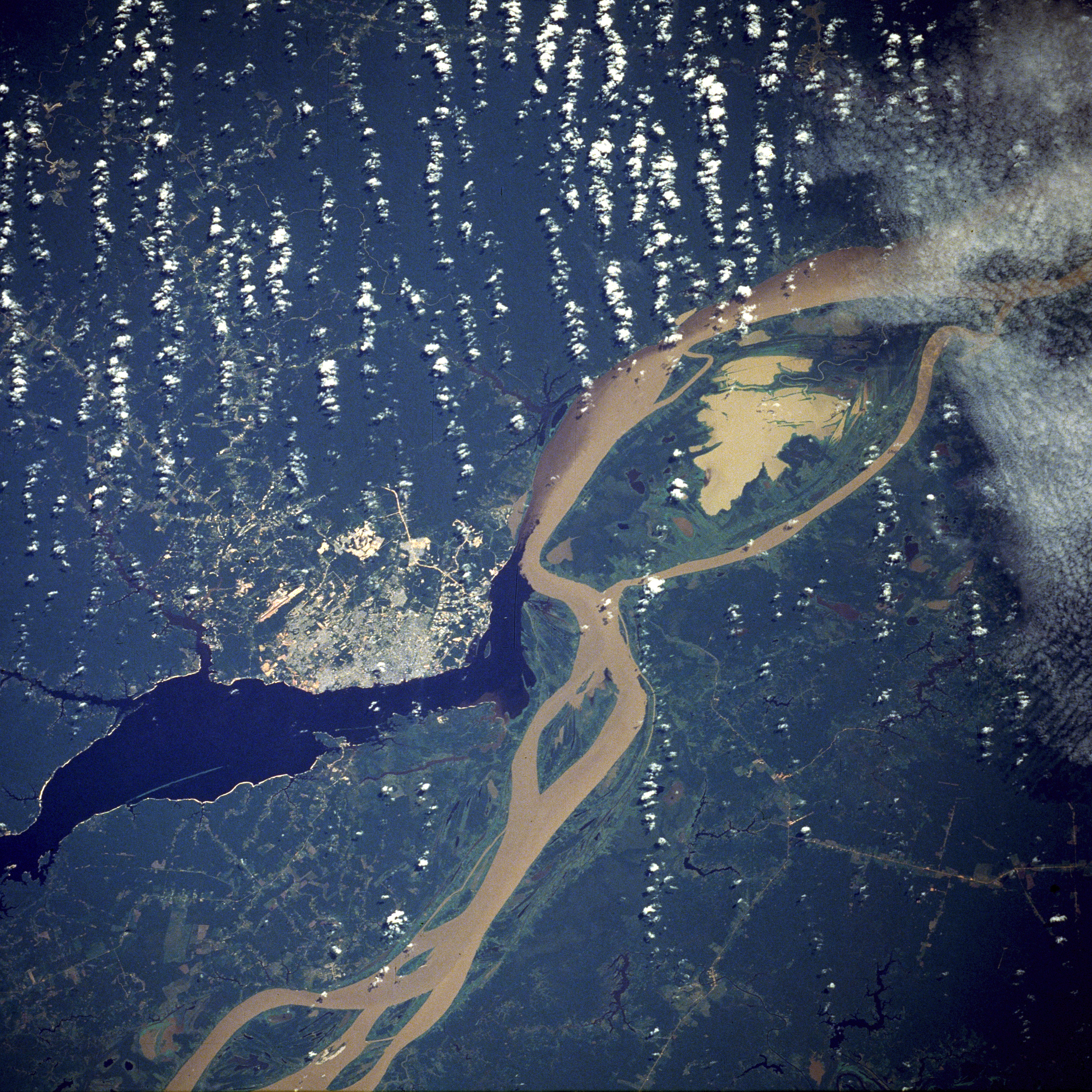
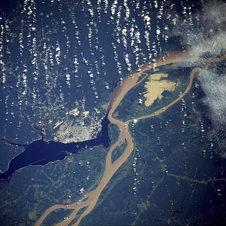
English: A satellite image of the city of Manaus with surrounding rivers.
English: Original caption:
- STS61C-33-84 Manaus, Amazonas, Brazil January 1986
- Two rivers and an urban area dominate this photograph. The largest city in the Amazon Basin, Manaus (with a 1994 population of 1.7 million), is located at the confluence of the Rio Negro (dark blue) and the Amazon River (lighter because of its high sediment content). The combined river flows eastward into the Atlantic Ocean. Situated approximately 800 miles (1290 kilometers) from the mouth of the Amazon River but accessible to oceangoing ships, Manaus is an important river port. This port city started to flourish in the late 1800s when the rubber boom was at its peak. Rubber, Brazil nuts, lumber, and assorted fruits are exported. In recent years, renewed interest in general development and the discovery of oil and manganese near Manaus have brought new importance to the city. A number of highways (linear, light-colored features), as well as a large commercial airport north of the city, are visible in the rain forest north and south of Manaus. North-south ground transportation is hindered because no bridges cross the Rio Negro or Amazon River. A large, sediment-laden lake (note irregular shoreline) is located east of Manaus between the main channel of the Amazon River and a smaller channel to the south.
Source
http://earth.jsc.nasa.gov/sseop/EFS/photoinfo.pl?PHOTO=STS61C-33-84 (file)
English: Photo credit: NASA
Este archivo fue catalogado por un de los centros de la Administración Nacional de Aeronáutica y del Espacio (NASA) de los Estados Unidos de Américabajo el identificador de foto: STS61C-33-84. Esta etiqueta no indica el estado de los derechos de autor del trabajo adjunto. Se requiere una etiqueta de derechos de autor normal. Para más información vea Commons:Sobre las licencias. Otros idiomas:
|
English-Wikipedia:
| date/time | username | edit summary |
|---|---|---|
| 10:52, 14 December 2004 | en:User:Magnus Manske | ({{PD-USGov-NASA}}) |
| 18:15, 18 June 2004 | en:User:Sverdrup | (Image info) |
| 18:14, 18 June 2004 | en:User:Sverdrup | (A satellite image of the city of <a href="/wiki/Manaus" title="Manaus">Manaus</a> with surrounding rivers.) |
Other version: Image:Manaus-Amazon-NASA2.jpg
See also

Licencia
| Este archivo es de dominio público porque fue creado por la NASA. Las políticas sobre copyright de la NASA estipulan que «el material de la NASA no está protegido con copyright a menos que se indique lo contrario». (Políticas sobre copyright de la NASA o Políticas sobre la utilización de imágenes del Jet Propulsion Laboratory). | ||
 |
Advertencias:
|
| Annotations | This image is annotated: View the annotations at Commons |
Amatl itlatolol
Haz clic sobre una fecha y hora para ver el archivo tal como apareció en ese momento.
| Tonallapohualpan ihuan imman | Pilixkopintsin | Octacayotl | Tekitiketl | TlahtoIcaquiliztiloni | |
|---|---|---|---|---|---|
| naman | 05:17 20 Īhuāncē 2011 | | 5312 × 5312 (8,7 MB) | Delirium | much higher-resolution version from the same source |
| 04:38 9 Īhuāncē 2011 |  | 640 × 640 (262 kB) | Creysmon07 | Corrected the contrast to a more realistic. | |
| 14:41 29 Cēn 2006 |  | 640 × 640 (157 kB) | Maksim | La bildo estas kopiita de wikipedia:en. La originala priskribo estas: A satellite image of the city of Manaus with surrounding rivers. '''Original caption:''' :''STS61C-33-84 Manaus, Amazonas, Brazil January 1986'' :''Two rivers and an urban area d |
In canin oquitlalihqueh
Ahmo oncah tlahcuiloliztli tlein quitzonhuilia nican.
can nohuiyanyoh motequipanoh inin tlachiyaliztecpaliztli
Las wikis siguientes utilizan este archivo:
- Uso en ar.wikipedia.org
- Uso en azb.wikipedia.org
- Uso en be.wikipedia.org
- Uso en bo.wikipedia.org
- Uso en ce.wikipedia.org
- Uso en cs.wikipedia.org
- Uso en de.wikipedia.org
- Uso en de.wikinews.org
- Uso en en.wikipedia.org
- Uso en en.wikinews.org
- Uso en eo.wikipedia.org
- Uso en et.wikipedia.org
- Uso en fa.wikipedia.org
- Uso en fi.wikipedia.org
- Uso en fr.wikipedia.org
- Uso en hr.wikipedia.org
- Uso en id.wikipedia.org
- Uso en ja.wikipedia.org
- Uso en li.wikipedia.org
- Uso en ml.wikipedia.org
- Uso en nl.wikipedia.org
- Uso en no.wikipedia.org
- Uso en pt.wikipedia.org
- Uso en ro.wikipedia.org
- Uso en ru.wikipedia.org
- Uso en sv.wikipedia.org
- Uso en uk.wikipedia.org
- Uso en ur.wikipedia.org
- Uso en www.wikidata.org
- Uso en zh-yue.wikipedia.org
- Uso en zh.wikipedia.org